Finally, after a long time of saying “yes, I will edit my town in OpenStreetMaps”, I really started editing.
There are different ways to edit OSM:
- Potlatch2 (P2) The main web editor on the same open street maps website.
- JOSM Java Open Street Maps editor
- Merkaator
The web interface is good enough to do some minor changes: attribute definition, add your favorite cafe etcetera. It also overlays the OSM data over a WMS of preference (bing,yahoo),handy things.
I actually have a preference on working locally with my computer and then uploading the data. JOSM and Merkaator seem equally valid, but there’s a killer-feature in Merkaator (at least for me): Shapefile loading :-). It should not be that important, but I have some data in shapefiles and it’s very easy to load it into Merkaator.
First View
Opening Merkaator is like opening ArcGIS or Qgis for the first time. A lot of stuff on the main window: Toolbars, menus, lists … A little bit overwhelming. But for basic edits most of this is actually not useful. You can run with basic toolbars (Layers and Properties.)
Cool Configuration
Nowadays we have Web map services everywhere: Open Street Maps, Google Maps, Bing Maps, Yahoo Maps. So editing OSM in a blank canvas makes you feel like a caveman. My town is in Catalunya, so instead of using Yahoo or Bing I can actually use ICC (Institut cartogràfic de Catalunya) WMS, that contains a lot of different layers, including a 5m Orthophoto.
Merkaator With plain ‘canvas’

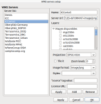
Set Up the WMS
Tools –> WMS Servers Editor
In my case, the WMS direction comes from ICC WMS

A cool thing about merkaator (in front of JOSM) is how this dialog works. First enter the URL of the WMS, and it automatically lists all the possible layers.
When you are done, simply save it.
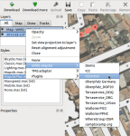
Activating the Layer
When the WMS Layer is set go to the layers Toolbar (by default on the left) Right click over the Map Layer and select the desired WMS adapter.

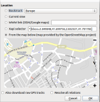
Download OSM data
Now it’s time to download the OSM data to edit. This is easy as pie:
There’s a huge icon called “Download”:
![]()
This button opens a self explanatory dialog, simply use the last option and the map to select a zone and download the data.

It’s also good to download the gps traces. If other users uploaded gps tracks in OSM you can rely on that data for mapping.
Downloading the data may take a while (depending on your connection and the amount of data). Sandwitch and cofee time!
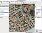
Ready to go!
With the OSM and WMS Layer loaded you have a delicious canvas to work on and check the “correctness” of your data.
Merkaator also lets you select the opacity of the OSM Layer.

Editing Something
When there is nothing at all on OSM (what happened in Lloret), you can start editing the main roads and the streets using the tags: highway=* (residential,road,pedestrian). There’s a full range of data and details to add!
OSM Beginner Guide
Upload your edits
Once you are satisfied with your changeset, upload it to the server using the upload icon. (The rusty megaphone icon)
![]()
A new dialog will appear showing a list of the changes and asking for a description.
Voilà
And the result of your hard work is now updated on OSM. It may take a while until the layers are rendered (usually not a lot).
Lloret de Mar Open Street Maps